
How Wisconsin Records Describe Your Neighbors
A Wisconsin neighbor search works best as a block check, not as a hunt for a list of private households. Parcel maps can show land shapes and adjacent addresses; assessor and deed records identify the owner or recorded transfer; voter and civic pages have their own narrow purpose. This first map of the sources separates what each can show from how a researcher can reach it. The same block may include a home, vacant parcel, park, school, business, church or public property, so adjacency alone does not identify who lives there.
| Wisconsin source | What it can show around one address | Access route |
|---|---|---|
| Wisconsin statewide or local parcel map | Parcel shapes, identifiers and nearby Wisconsin site-address or owner fields | Public Wisconsin map; confirm current data with the local land-information source |
| Wisconsin municipal assessor | Owner, assessed property details, situs and tax-mail address where published | Wisconsin local assessor search or office request |
| Wisconsin Register of Deeds | Recorded Wisconsin deeds, plats and other parcel instruments | County index, available online search, counter or older books |
| Wisconsin MyVote and voter list | Polling and ballot information by address; permitted registration fields by request | Personal lookup online or written request to WEC or local clerk |
| Wisconsin municipal neighborhood page | Public organization boundary, contact and meeting information | City, village or town directory; member rosters are not presumed public |
| Wisconsin permits and historic maps | Some dated parcel work, past lot form and buildings | Municipal portal or records custodian; library, WHS or Area Research Center |
These records support different claims: a map locates parcels, an assessor roll connects an owner to property, and an organization page identifies a civic contact or boundary. They do not establish every occupant or household relationship. Use the rest of the Wisconsin neighbor lookup to move from one address outward, then verify an important fact with the office that keeps that record.
Map a Wisconsin Neighbor Block
Start with a known Wisconsin street address in the Wisconsin Statewide Parcel Map or Wisconsin county GIS. The state map supports location search, map browse, parcel selection and an identify pop-up. Click the target polygon, record its Wisconsin parcel ID and note the owner, physical site address and mailing fields, then inspect each nearby polygon that shares a boundary or frontage. A road, alley, waterway, condominium common area or easement can make a simple visual guess about adjacency wrong, so confirm the parcel and boundary against local information.
- Search for the Wisconsin address or navigate the map to the right block, then select the target parcel.
- Write down its Wisconsin parcel ID, site address, owner field, mailing address and the date or source version shown.
- Select the parcels that touch or front the target and compare their identifiers and public fields; note roads, alleys, water and common parcels that interrupt an apparent boundary.
- Use the Wisconsin local assessor or land-information source to confirm current assessment details, then check the county Register of Deeds for a recorded transfer when ownership is the question.
The Wisconsin statewide layer is a map and discovery aid, not a survey or proof of legal ownership lines. If the question expands from the few parcels around one address to all records along a named street, the Wisconsin street directory guide covers that broader address chain.
Wisconsin Neighbors Have Four Address Clues
Wisconsin property systems keep several location labels for one place. A Wisconsin parcel's site or situs address points to the physical land; an owner's mailing address is where tax mail is sent; a USPS last line is a delivery label; and a Wisconsin legal description identifies the recorded land. These can differ without an error. An owner may use a different mailing address, and a Wisconsin legal description may name a subdivision lot or public land survey section rather than a street address. Comparing them can help explain why two sources appear to disagree.
The State Cartographer's Office V12 parcel data combines about 3.56 million Wisconsin parcel records from all 72 counties. Its source data was gathered during the first half of 2026, and most tax-roll years are 2025; some small areas are not digitally mapped. The feature layer can include owner names, full site and mailing addresses, parsed address fields, parcel geometry, county, municipality and legal or PLSS clues. This scale is useful for discovery around the block, but the local assessor is the current source for Wisconsin assessment details. Ask the local office to resolve an owner, parcel-key or address mismatch.
The Wisconsin statewide data page also warns that map shapes are not legal ownership boundaries. If a property line matters, use the Wisconsin recorded deed or plat and seek the appropriate survey professional. A layer shown for zoning, flood, school or planning context can help describe a block, but it does not turn a map into a title record or a list of people.
Wisconsin MyVote Does Not List Neighbors
MyVote's Wisconsin address search is for polling-place and ballot context, not the names of residents or voters at an address. Its other route lets a voter check their own registration. For a block-level civic question, keep those functions separate from a permitted request for Wisconsin voter-file data. The Wisconsin public list has protections and cannot be treated as a complete picture of who lives on a street.
| MyVote or voter-list path | Fields or request details | What it can provide |
|---|---|---|
| Address lookup | Wisconsin street address, unit, city and ZIP | Polling place and ballot information for that address. |
| Personal name lookup | First name, last name and birth date | The voter's own Wisconsin registration record and participation history. |
| Public voter-list report | Wisconsin written request or request reduced to writing; name fields, geography, date range and format | Permitted nonprotected data through WEC or a Wisconsin county or municipal clerk. |
The MyVote My Voter Info page displays both personal paths. A public or custom report is handled by the Wisconsin Elections Commission or a local clerk under Wis. Stat. § 6.36 and Wis. Admin. Code EL 3.50. Wisconsin electronic data reports carry a $25 base charge plus $5 for each thousand-record increment, up to $12,500; paper copies cost $0.25 a page plus postage and shipping. The public record may include registration address, ward or precinct, status and participation history where allowed. Date of birth, driver's-license number, Social Security number, confidential-elector address and voting-accommodation indicator are protected. Do not infer party choice or ballot selections from any of these fields.
Wisconsin confidential electors are kept off the public portion of the voter list. An apparent absence of voter data near a Wisconsin address does not show that nobody is registered there. It can mean the search is for a different purpose, protected Wisconsin information is withheld, or no public field is available to answer the question.
Madison and Milwaukee Neighborhood Groups
Wisconsin has no statewide official directory of every neighborhood association. The useful route is local: start with the Wisconsin city, village or town neighborhood-engagement page, then check a county planning office, public library directory or umbrella group. These pages can publish a neighborhood boundary, public contact or meeting time. They do not establish that a person lives in that area or belongs to an association.
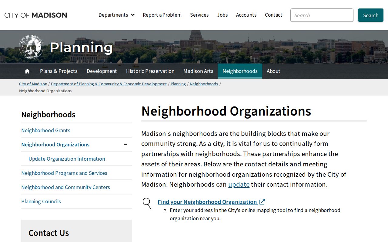
The City of Madison's recognized-neighborhood page in Wisconsin offers an address-based organization map, public contacts, meeting details and a way for groups to update their public information. Its Wisconsin update route collects organization and contact details, meeting schedule, boundary changes, maps, events and publications; it is an update to civic information, not a member roster. The City of Milwaukee's neighborhood page in Wisconsin describes associations and map boundaries, while warning that planning boundaries need not match association boundaries.
The Madison, Wisconsin, organizations page shows its address-based map and public contact route, which can help identify the right civic group for a block.
These are Wisconsin examples of the kind of public contact layer a municipality may maintain; they are not a complete statewide roster. Use the Wisconsin local page's listed contact method or meeting details to connect with a group, and check when the information was last updated. Where no public member directory is available, do not infer membership from a parcel or address.
Madison, Wisconsin, recognized-neighborhood organizations
Public details
Map by address, organization contacts, meeting information and update route.
Milwaukee, Wisconsin, neighborhood associations
Public details
Neighborhood descriptions, association links and a contact-update path; planning and association boundaries may differ.
Wisconsin Neighbors: Official Records and Commercial Tools
Official Wisconsin records are strongest when the question concerns a specific parcel, filing or civic contact. Each comes from a named Wisconsin custodian and has a dated scope. Commercial neighbor tools compile public, licensed and marketing data into a single report, which can be convenient for a broad starting point but can mix people with similar names or repeat an old address. Neither type of result should be treated as a verified household roster; confirm relevant facts with the Wisconsin source that created them.
| Source type | What it is suited to show | Limit to keep in view |
|---|---|---|
| Wisconsin parcel, assessor and deed records | Land shape, listed owner, tax or recorded transfer details | Ownership does not establish who occupies the parcel; dates and local coverage vary. |
| Wisconsin election and civic records | Polling context, permitted voter-list fields, public organization contacts | Protected voter fields and private member details are not a public roster. |
| Commercial compiled profiles | A combined set of data points gathered from multiple sources | Identity matching, freshness, completeness and correction vary; verify through the custodian. |
Sanborn Maps Track Wisconsin Block Changes
For a Wisconsin block's earlier shape, compare modern parcel data with a plat, atlas or fire-insurance map. The Wisconsin Historical Society holds Sanborn maps for 325 communities, with editions from 1883 through 1930. Pre-1923 maps are digitized online, and the Society's in-person Wisconsin collections can cover later editions. The Society also describes more than 700 digitized map sets created in 1926 or earlier. These maps can show building footprints, lot lines, streets and some land-use features for their own date.
Use the Wisconsin Historical Society Sanborn collection guide or contact a Wisconsin library or Area Research Center for a sheet. A map shows historical physical context, not today's occupants or legal ownership. A Wisconsin street name, parcel split or building change may explain why a past directory entry no longer lines up neatly with a current map. Cite the map year and community when using it alongside a modern block search.
Wisconsin Permits Date Block Changes
A Wisconsin municipal permit, inspection or code file can add a dated clue about work at a particular address. The actual public fields depend on the city or village, and an open investigation or protected complainant detail may be redacted. Search a Wisconsin local portal if one exists, then ask the municipal records custodian for the record or a public terminal route. The City of Madison's records-custodian page illustrates how a Wisconsin resident can find a department and submit a request; its process is an example rather than a statewide system.
Wisconsin Public Records Law, Wis. Stat. §§ 19.31-19.39, applies to records held by Wisconsin state and local authorities subject to exceptions and a balancing test. Describe the permit, parcel, address or date range rather than asking the office to identify people. There is no fixed universal response deadline; a Wisconsin authority responds as soon as practicable and without delay. Fees may cover actual, necessary and direct costs for reproduction, locating, processing and delivery, and prepayment may be required in some cases. If the portal has no index, the Wisconsin custodian, clerk counter or local library can explain whether a paper, archived or historical series survives.
Limits on Wisconsin Neighbor Searches
A public parcel record names land and listed ownership, not everyone who may live there. Voter data is limited by protected fields, and association pages publish civic contacts rather than private member lists. Utility-customer details and personal household information are not open block directories. A business, school, church, park, vacant parcel, trust or government office can sit next door, so describe adjacent parcels as map findings and avoid labeling an occupant without a source that supports it.
Wisconsin Safe at Home participants use an assigned substitute address and may be confidential electors whose actual addresses do not appear in the public voter list. Qualifying Wisconsin judicial officers and family members have additional address protections. If a public page exposes a protected field or an official record is wrong, contact its Wisconsin custodian about correction or redaction. Use neighborhood information for a lawful civic or personal purpose and verify current Wisconsin details before sharing them.
Respect privacy. Keep a Wisconsin neighbors search focused on parcels, public civic contacts and the question at hand. Do not use it to expose, watch, threaten or harass a person.